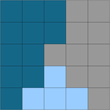
Area of classified objects
Map features > Objects > Area of classified objectsThe absolute area of all image objects classified as a given class. Default unit is pixels.
Editable Parameters
- Class: select or insert class name
Parameters
-
is an image object
-
is a given class
-
are all image objects classified as
-
is the total number of pixels of image object
Expression
Feature Value Range
Area of classified objects in region
Map features > Objects > Area of classified objects in regionThe absolute area of all image objects classified as a given class on a given image object level within a region. This feature allows the user to refer to a region and image object level. If the region is not defined (i.e. set to "none") the entire scene extent will be used. Default unit is pixels.
Editable Parameters
- Region
- Class
- Level
Parameters
is the total number of pixels
is the given image object level
is the given region
is the given class
Expression
Feature Value Range
Area percentage of
Map features > Objects > Area percentage ofThe feature divides the area of one class by the area of another class.
Editable Parameters
- Class
- Other Class
Parameters
is the total number of pixels of class n
is the total number of pixels of class m
Expression
Feature Value Range
Existence of object level
Map features > Objects > Existence of object levelThe feature returns 1 if a defined object level exists and to 0 if it does not exist.
Editable Parameters
- Level name
Histogram of object value
Map features > Objects > Histogram of object valueCalculates the histogram for objects of a selectable class and feature. The output can be written in an array.
Editable Parameters
- Class: select or insert class name
- Feature: select the feature for statistical calculation
- Slots: select the number of slots in histogram
- Type: select the type of the histogram (Frequency or Relative frequency)
Layer StdDev of classified objects
Map features > Objects > Layer StdDev of classified objectsThe standard deviation of all image objects of the selected class on a selected image object level.
Editable Parameters
- Class: select or insert class name
- Image layer: select the layer for statistical calculation
Parameters
-
is an image object
-
is a given class
-
are all image objects classified as
-
is the mean intensity of layer
for image object
Expression
Feature Value Range
Layer Mean of classified objects
Map features > Objects > Layer Mean of classified objectsThe mean of all image objects of the selected class on the selected image object levels.
Editable Parameters
- Class: select or insert class name
- Image layer: select the layer for calculation
Parameters
-
is an image object
-
is a given class
-
are all image objects classified as
-
is the mean intensity of layer
for image object
Expression
Feature Value Range
Number of classified objects
Map features > Objects > Number of classified objectsThe absolute number of all image objects of the selected class on all image object levels.
Editable Parameters
- Class: select or insert class name
Parameters
-
are all image objects classified as
-
is a given class
Expression
Feature Value Range
Relative area of classified objects in region
Map features > Objects > Rel. area of classified objects in regionThe relative area in pixels of all image objects of a given class on a given image object level within a region.
Editable Parameters
- Region
- Class
- Image object Level
Parameters
is the total number of pixels
is the given image object level
is the given region
is the given class
Expression

|
Class |
Area of classified objects |
Relative area of classified objects |
|---|---|---|
|
|
11 pixels |
11/25 = 0.44 |
|
|
10 pixels |
10/25 = 0.4 |
|
|
4 pixels |
4/25 = 0.16 |
Feature Value Range
Statistic of object value
Map features > Objects > Statistic of object valueThis feature allows the calculation of statistical operators over an existing object’s feature.
Editable Parameters
- Class: select or insert class name
- Statistical Operation (Number, Min, Max, Mean, Sum, StdDev)
- Feature: select the feature for statistical calculation
All existing image object levels
Map features > Objects > All existing image object levelsReturns the names of all image object levels.
Number of objects
Map features > Objects > Number of objectsReturns the number of image objects of the current map.


